


Chemin de St-Guilhem 6 variante

cron
User
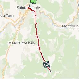

Length
15.1 km

Max alt
1032 m

Uphill gradient
717 m
Km-Effort
23 km

Min alt
464 m

Downhill gradient
236 m
Boucle
No
Creation date :
2019-01-15 16:40:28.719
Updated on :
2019-07-10 21:50:18.067
5h03
Difficulty : Medium

FREE GPS app for hiking
 SityTrail
IGN / Geographical institutes
SityTrail Plus
The world is yours!
About
Trail Walking of 15.1 km to be discovered at Occitania, Lozère, Gorges du Tarn Causses. This trail is proposed by cron.
Positioning
Country:
France
Region :
Occitania
Department/Province :
Lozère
Municipality :
Gorges du Tarn Causses
Location:
Sainte-Enimie
Start:(Dec)
Start:(UTM)
532847 ; 4912621 (31T) N.
Comments